About company
ErmaSoft Management (ErmaSoft) – the Russian company, working in the area of high-tech applications.
Knowledge and experience, stored for over 25 years, place the company among the leaders in the field of development and implementation of geoinformation technologies-assisted program-functional systems.
ErmaSoft has a large stack of implemented projects and all the necessary facilities for achievement and support of complex solutions.
Priority business guidelines
|

|
business-process analysis, IT and geoinformation systems. Appraisal, organizational and technological support of geoinformation projects |
|
|
design of computer-based data-graphic systems. Software development for functional systems using geoinformation techniques |
|
|
database development, scanning and digitalization of maps, building and terrain layouts. Maintenance of address registries |
|
|
implementation and integration with existent information systems |
|
|
authorized support of project solutions |
ErmaSoft progressively invests in research and development of program-informational products, providing Customers with the advanced technologies and tools.
ErmaSoft executes the orders for the sake of governmental and proprietary organizations. Top-level Russian scientific organizations serve as our projects implementation partners.
ErmaSoft solutions are practically working and offer a actual cost-performance.
ErmaSoft is a base enterprise of the “System integration and management” chair of the Moscow Applied Physics Institute and “Cybernetics” chair of the Moscow Physics Engineering Institute (MPEI Technical University). General Director, research manager of ErmaSoft: Ph. D., assistant professor at the “System integration and management” chair of MAPI, corresponding member of Russian Academy of Natural Sciences – Mikhail Sudeikin.
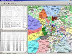
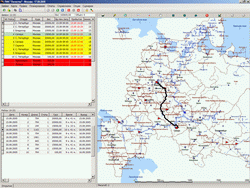
Goods delivery scheduling
|
Solvable tasks:
scheduling of the products delivery to the clients –
number of vehicles, routes and arrival times
efficient projection of carload for each vehicle route lists and summary way-bills generation
route lists and summary way-bills generation
|
 |
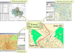
Mobile units monitoring
|
Integrated system provides:
routes projection and temporal corridor establishing
visual monitoring, units migration control and message exchange with control center
planned and actual migration schedules comparison, cumulative data processing and analysis |
 |
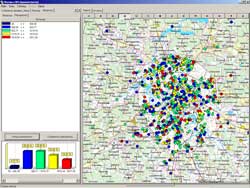
Sales analysis and management
|
Solvable tasks:
support of "Customers" and "Agent responsibility areas" databases, coupled with cartographical background
L&R
agents performance analysis and scheduling
creation and editing of "Agent activity zones"
|
 |
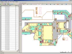
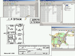
Buildings and adjacent area administration
Technical documents repository
|
Solvable tasks:
development of an alphanumeric database containing technical drawings' specifications
development of a graphical database determining location of technical drawings on the floor plans of the Technical Inventory Bureau
scanning of the technical documentation and creation of the electronic copies library
integration of databases and electronic copies into the technical documents repository
|
 |
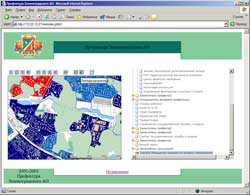
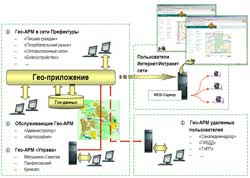
Municipal geoinformation systems
|
Multi-user geoapplication with a set of geo-workstations:
in the Prefecture network
at the remote users cites
in the Internet network
service geo-workstations
Incorporates:
cartographical background
address data
subject data for administrative and managerial solutions support |
 |
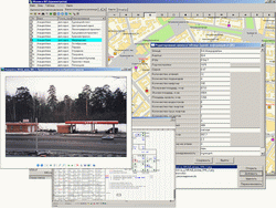
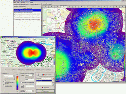
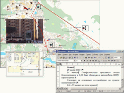
Competitive environment monitoring
|
Solvable tasks:
data unification for the purpose of a visual snap (objects' location, ownership, sales volume, range of choice, price characteristics, object photos...)
customer network broadening subject to transport and passenger traffic and sales outlets
|
 |
Freight services sales monitoring
Solvable tasks:
mapping of the logistic chain members - third persons
visualization of freight layouts
definition of the freight units and their specifications
transport operations performance control
|
 |
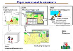
Social safety map for kids and teenagers
Geoinformation systems in education
Solvable tasks:
preparation of methodical sources on the usage of special design offices in the educational system, administrative and managerial structures
holding seminars for heads of educational structures, educational specialists in security and information science, social services |
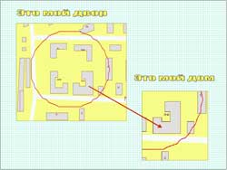 |
Geoinformation systems in security
Enables:
development of primary and reserve track for the guarded person and fast response group
inclusion into the plan of supplementary sources for real-time decision-making
capturing of on-line situation information on the places of residence of the guarded person
|
 |
I&R geo-applications
Embedding of geoapplication into WEB-pages
ERMA SOFT Management
Phone: +7 (495) 968 02 80
WWW: ermasoft.ru
E-mail: erma@ermasoft.ru
|